National Geographic
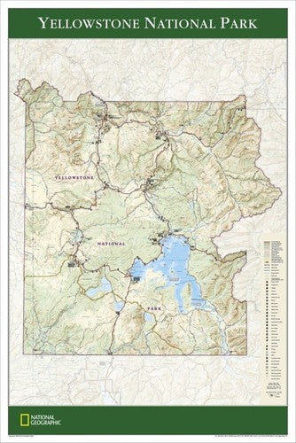
Yellowstone National Park Wall Map - Standard (24" x 36")
Yellowstone National Park Wall Map - Standard (24" x 36")
Couldn't load pickup availability
National Geographic Yellowstone National Park Wall Map — Standard, 24" x 36". Trails Illustrated base cartography. Rolled (not tubed).
The Yellowstone National Park Wall Map covers the world's first national park with detailed topography, geothermal features, wildlife habitats, and the full trail and road system. Old Faithful, Grand Prismatic Spring, Mammoth Hot Springs, the Grand Canyon of the Yellowstone, major campgrounds, visitor centers, and key landmarks across Yellowstone's 2.2 million acres spanning Wyoming, Montana, and Idaho are all shown.
Key specs
- SKU: NGWM206
- Size: 24" x 36"
- Format: Standard (rolled)
- Material: High-quality paper print
- Series: Trails Illustrated Wall Map
- Coverage: Full Yellowstone National Park (WY/MT/ID)
Why it works
Yellowstone's 2.2 million acres contain the world's largest concentration of geothermal features, extensive wildlife habitat, and hundreds of miles of trails — a large-format wall map captures the full park in readable detail, useful for pre-trip planning and striking as a display piece. The standard rolled format is the economical option for buyers who don't need tube protection.
Ideal for
Trip planning, home or office display, and as a gift for Yellowstone visitors, national park enthusiasts, and outdoor lovers. See also the Tubed edition (NGWM207) for protected shipping.
Share