National Geographic
Pacific Crest Trail Wall Map - Laminated
Pacific Crest Trail Wall Map - Laminated
Couldn't load pickup availability
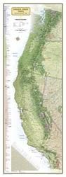
National Geographic Pacific Crest Trail Wall Map — Laminated. Full 2,650-mile trail from the Mexican border through CA, OR, and WA to the Canadian border. Durable laminated finish for frequent reference.
The Pacific Crest Trail Wall Map (Laminated) displays the entire 2,650-mile PCT from the Mexican border at Campo, California through the Sierra Nevada, Oregon Cascades, and Washington's North Cascades to the Canadian border at Manning Park. Major landmarks, resupply towns, wilderness areas, national parks, and elevation changes are all shown. The laminated finish protects the map for repeated handling during trip planning.
Key specs
- SKU: NGWM168
- Format: Laminated wall map
- Coverage: Full Pacific Crest Trail — Mexican border to Canadian border (2,650 miles)
- Features: Landmarks, resupply towns, wilderness areas, national parks, elevation changes
- Finish: Durable lamination for repeated use and dry-erase marking
Why it works
The PCT passes through some of the American West's most spectacular terrain — the Mojave Desert, John Muir Trail corridor, Crater Lake, and the North Cascades. A laminated wall map lets you trace the full route, mark waypoints, and plan resupply logistics without worrying about wear. It's equally at home as a planning tool and as a display piece celebrating a completed hike.
Ideal for
PCT thru-hikers and section hikers for trip planning, and as a display piece for completed hikers and trail enthusiasts.
Share