National Geographic
Continental Divide Trail Wall Map - Laminated
Continental Divide Trail Wall Map - Laminated
Couldn't load pickup availability
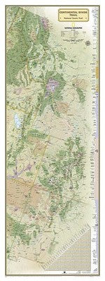
National Geographic Continental Divide Trail Wall Map — Laminated. Full 3,100-mile trail from the Mexican border through NM, CO, WY, ID, and MT to the Canadian border. Durable laminated finish for frequent reference.
The Continental Divide Trail Wall Map (Laminated) displays the entire 3,100-mile CDT from the Mexican border at Antelope Wells, New Mexico along the spine of the Rocky Mountains through Colorado, Wyoming, Idaho, and Montana to the Canadian border at Waterton Lakes. Major landmarks, resupply towns, wilderness areas, national parks, and dramatic elevation changes are all shown. The laminated finish protects the map for repeated handling during trip planning.
Key specs
- SKU: NGWM165
- Format: Laminated wall map
- Coverage: Full Continental Divide Trail — Mexican border to Canadian border (3,100 miles)
- Features: Landmarks, resupply towns, wilderness areas, national parks, elevation changes
- Finish: Durable lamination for repeated use and dry-erase marking
Why it works
The CDT is the most remote and challenging of the Triple Crown trails, following the Continental Divide through some of the American West's wildest terrain — the Gila Wilderness, Colorado's San Juan Mountains, Wyoming's Wind River Range, and Glacier National Park. A laminated wall map lets you plan the full route, mark progress, and understand the geographic scope of this epic journey without worrying about wear.
Ideal for
CDT thru-hikers and section hikers for trip planning, and as a display piece for completed hikers and Triple Crown enthusiasts.
Share