National Geographic
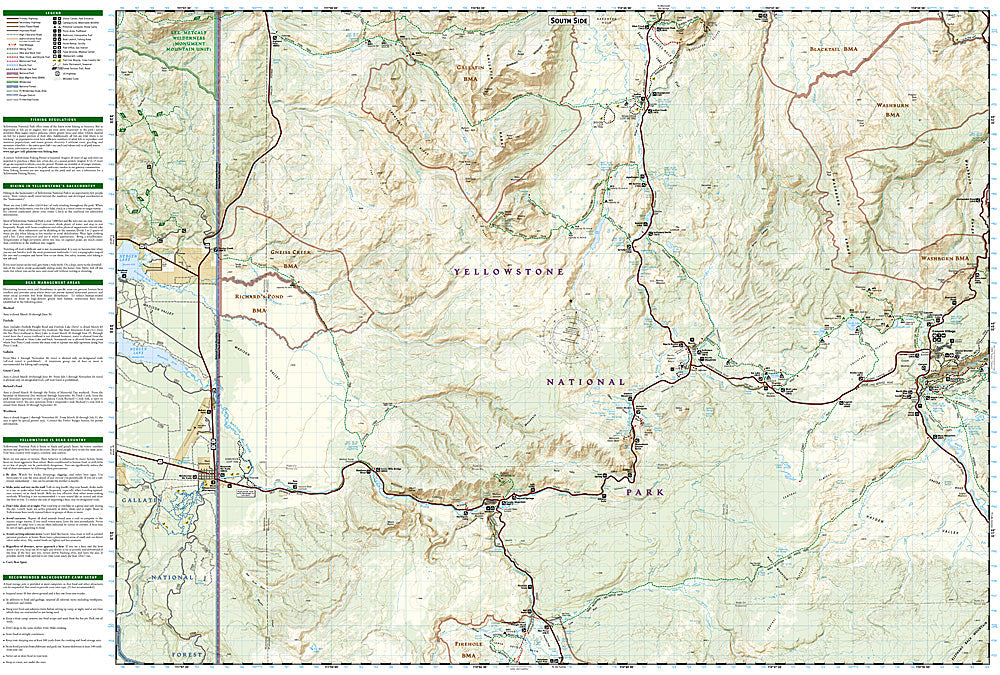
NW Yellowstone, Mammoth Hot Springs: Map #303
NW Yellowstone, Mammoth Hot Springs: Map #303
Couldn't load pickup availability
National Geographic Trails Illustrated NW Yellowstone & Mammoth Hot Springs Map #303 — waterproof, tear-resistant. Coverage of the northwestern Yellowstone National Park quadrant including Mammoth Hot Springs, the Gallatin Range, and the park's northern entrance corridor. GPS-compatible.
The National Geographic Trails Illustrated NW Yellowstone & Mammoth Hot Springs Map covers the northwestern quadrant of Yellowstone National Park — Mammoth Hot Springs (the park's headquarters and iconic travertine terraces), the Gallatin Range backcountry, the Blacktail Deer Plateau, and the northern entrance corridor through Gardiner, Montana. Trails, thermal features, backcountry campsites, wildlife viewing areas, and GPS coordinates are mapped in detail.
Key specs
- SKU: NGTI303
- Map number: 303
- Coverage: NW Yellowstone & Mammoth Hot Springs, Yellowstone National Park, Wyoming/Montana
- Material: Waterproof, tear-resistant paper
- Features: Trails, Mammoth terraces, Gallatin Range, Blacktail Plateau, backcountry campsites, GPS coordinates
Why it works
The Mammoth area is Yellowstone's year-round hub and the only section of the park accessible by road in winter, with the travertine terraces and surrounding backcountry requiring detailed feature location and trail mapping. The Gallatin Range's remote backcountry terrain provides some of Yellowstone's best wilderness hiking away from the thermal features. Waterproof construction survives Yellowstone's variable weather and the thermal environment near Mammoth's hot springs.
Ideal for
Hikers, backpackers, wildlife watchers, and park visitors exploring Mammoth Hot Springs, the Gallatin Range, and the northwestern Yellowstone backcountry. See also NGTI201 (Yellowstone National Park) for full park coverage.
Share