National Geographic
Tarryall Mountains, Kenosha Pass: Map #105
Tarryall Mountains, Kenosha Pass: Map #105
Couldn't load pickup availability
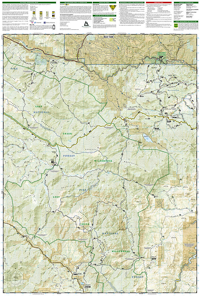
National Geographic Trails Illustrated Tarryall Mountains & Kenosha Pass Map #105 — waterproof, tear-resistant, scale 1:40,000. Coverage of the Lost Creek Wilderness, Tarryall Mountains, Kenosha Pass, and Colorado Trail segments in Pike National Forest. GPS-compatible.
The National Geographic Trails Illustrated Tarryall Mountains & Kenosha Pass Map covers the Lost Creek Wilderness and surrounding Pike National Forest — the Lost Creek Wilderness's unique granite formations, Kenosha Pass (a premier Colorado Trail access point), Tarryall Reservoir, and surrounding terrain. Trails, Colorado Trail route, wilderness boundaries, equestrian routes, and GPS coordinates are mapped in detail.
Key specs
- SKU: NGTI105
- Map number: 105
- Scale: 1:40,000
- Coverage: Tarryall Mountains & Kenosha Pass area, Pike National Forest, Colorado
- Material: Waterproof, tear-resistant paper
- Features: Trails, Lost Creek Wilderness, Colorado Trail, Kenosha Pass, equestrian routes, GPS coordinates
Why it works
Kenosha Pass is one of the most popular Colorado Trail access points from Denver, with the aspen groves on the pass providing spectacular fall color — detailed trail and Colorado Trail mapping is essential for day hikers and backpackers accessing the CT from this trailhead. The Lost Creek Wilderness's maze of granite formations and the creek's disappearing act underground make accurate topographic mapping essential for navigation. Waterproof construction survives the Pike National Forest's afternoon thunderstorms.
Ideal for
Hikers, backpackers, equestrians, and Colorado Trail users exploring the Lost Creek Wilderness and Kenosha Pass area in Pike National Forest. See also NGTI152 (Elevenmile Canyon, South Park) for adjacent coverage to the south.
Share