National Geographic
Breckenridge, Tennessee Pass: Map #109
Breckenridge, Tennessee Pass: Map #109
Couldn't load pickup availability
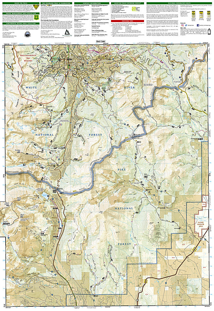
National Geographic Trails Illustrated Breckenridge & Tennessee Pass Map #109 — waterproof, tear-resistant, scale 1:40,000. Coverage of the Breckenridge area, Tenmile Range, Tennessee Pass, Holy Cross Wilderness approach, and surrounding White River and Arapaho National Forests. GPS-compatible.
The National Geographic Trails Illustrated Breckenridge & Tennessee Pass Map covers the Breckenridge area and Tennessee Pass corridor — the Tenmile Range, Quandary Peak (14,265 ft), the Continental Divide Trail, Colorado Trail, Tennessee Pass, and surrounding national forest lands. Trails, CDT/CT routes, ski terrain, 10th Mountain Division hut system, trailheads, and GPS coordinates are mapped in detail.
Key specs
- SKU: NGTI109
- Map number: 109
- Scale: 1:40,000
- Coverage: Breckenridge & Tennessee Pass area, Colorado
- Material: Waterproof, tear-resistant paper
- Features: Trails, Quandary Peak route, CDT/Colorado Trail, 10th Mountain huts, ski terrain, GPS coordinates
Why it works
Breckenridge is one of Colorado's most popular four-season destinations, with Quandary Peak being one of the most climbed 14ers in the state due to its accessibility from the town. The 10th Mountain Division hut system's Tennessee Pass area huts require accurate hut location and ski route mapping for winter backcountry travel. Waterproof construction survives the Tenmile Range's afternoon thunderstorms and the heavy snowpack common in Summit County.
Ideal for
Hikers, mountaineers, skiers, CDT/Colorado Trail users, and 10th Mountain hut-to-hut travelers exploring the Breckenridge and Tennessee Pass area. See also NGTI108 (Vail, Frisco & Dillon) for adjacent coverage to the north.
Share