National Geographic
Lake Tahoe Basin: Map #803
Lake Tahoe Basin: Map #803
Couldn't load pickup availability
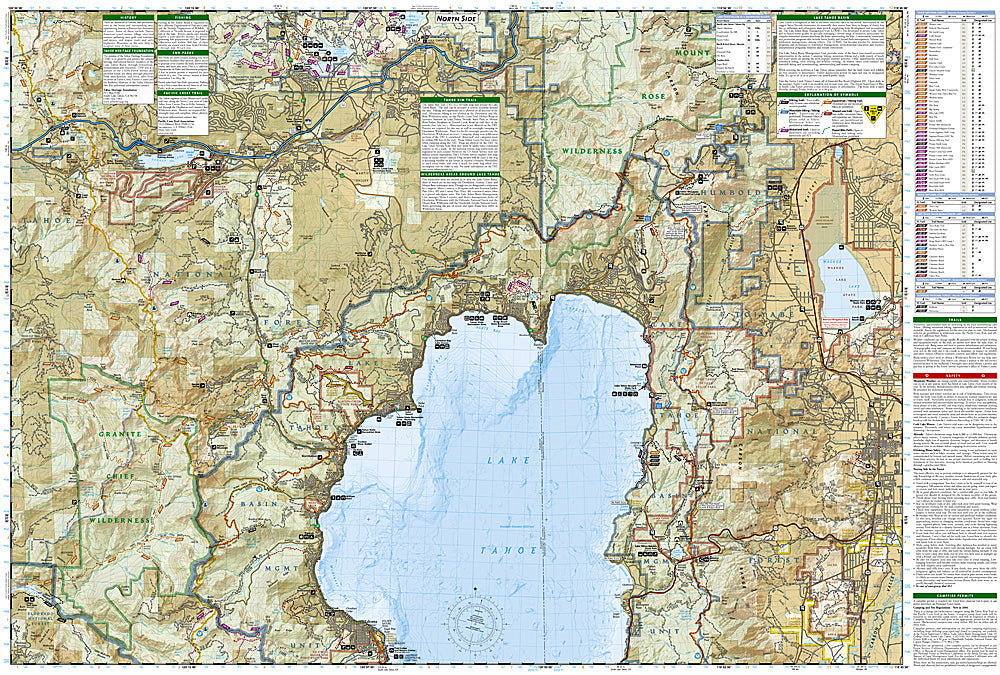
National Geographic Trails Illustrated Lake Tahoe Basin Map #803 — waterproof, tear-resistant. Comprehensive coverage of the Lake Tahoe Basin including the Tahoe Rim Trail, Desolation Wilderness, and surrounding national forest lands in California and Nevada. GPS-compatible.
The National Geographic Trails Illustrated Lake Tahoe Basin Map provides comprehensive coverage of the full Lake Tahoe Basin — the Tahoe Rim Trail (165-mile loop), Desolation Wilderness, Granite Chief Wilderness, beaches, ski areas, and surrounding Tahoe National Forest and Lake Tahoe Basin Management Unit lands. Trails, TRT route, wilderness boundaries, beaches, campgrounds, and GPS coordinates are mapped in detail.
Key specs
- SKU: NGTI803
- Map number: 803
- Coverage: Lake Tahoe Basin (CA/NV)
- Material: Waterproof, tear-resistant paper
- Features: Tahoe Rim Trail, Desolation Wilderness, beaches, ski areas, campgrounds, GPS coordinates
Why it works
Lake Tahoe's basin encompasses two states, multiple national forests, and a complex mix of public and private land — a single comprehensive map covering the full basin is far more practical than managing multiple individual maps for different sections. The Tahoe Rim Trail's 165-mile loop and the Desolation Wilderness's permit zone boundaries require accurate mapping for planning compliant visits. Waterproof construction survives the Sierra Nevada's afternoon thunderstorms and the lake environment.
Ideal for
Hikers, mountain bikers, boaters, skiers, and outdoor enthusiasts exploring the full Lake Tahoe Basin. See also NGTI1013 (Tahoe Rim Trail) for dedicated TRT coverage and NGTI802 (Desolation & Granite Chief Wilderness) for wilderness detail.
Share