National Geographic
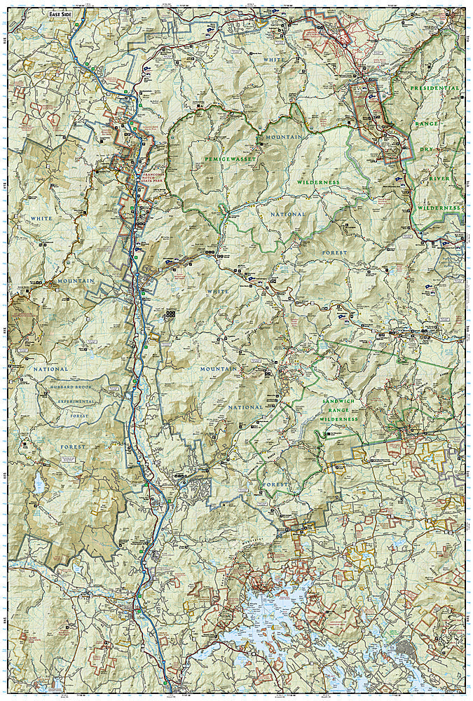
Franconia Notch, North Conway: Map #740
Franconia Notch, North Conway: Map #740
Couldn't load pickup availability
National Geographic Trails Illustrated Franconia Notch & North Conway Map #740 — waterproof, tear-resistant. Coverage of Franconia Notch State Park, the Kinsman and Franconia Ranges, North Conway, and surrounding White Mountain National Forest in New Hampshire. GPS-compatible.
The National Geographic Trails Illustrated Franconia Notch & North Conway Map covers the western and eastern White Mountains — Franconia Notch State Park (Cannon Mountain, Flume Gorge, Echo Lake), the Franconia Ridge Loop (one of the most popular hikes in the Northeast), North Conway's climbing areas, and surrounding White Mountain National Forest. Trails, AT corridor, AMC huts, climbing areas, and GPS coordinates are mapped in detail.
Key specs
- SKU: NGTI740
- Map number: 740
- Coverage: Franconia Notch & North Conway area, White Mountain National Forest, New Hampshire
- Material: Waterproof, tear-resistant paper
- Features: Trails, Franconia Ridge Loop, AT corridor, AMC huts, North Conway climbing areas, GPS coordinates
Why it works
The Franconia Ridge Loop is consistently rated one of the best day hikes in the eastern US, with the above-treeline ridge traverse requiring accurate trail and terrain detail for safe navigation in the White Mountains' notoriously unpredictable weather. North Conway's Cathedral Ledge and Whitehorse Ledge are world-class rock climbing destinations requiring detailed approach and route mapping. Waterproof construction survives the White Mountains' frequent rain and the variable weather common in the notches year-round.
Ideal for
Hikers, rock climbers, AT section hikers, and outdoor enthusiasts exploring Franconia Notch, the Franconia Ridge, and North Conway in New Hampshire's White Mountains. See also NGTI741 (Presidential Ridge & Gorham) for adjacent coverage to the north.
Share