National Geographic
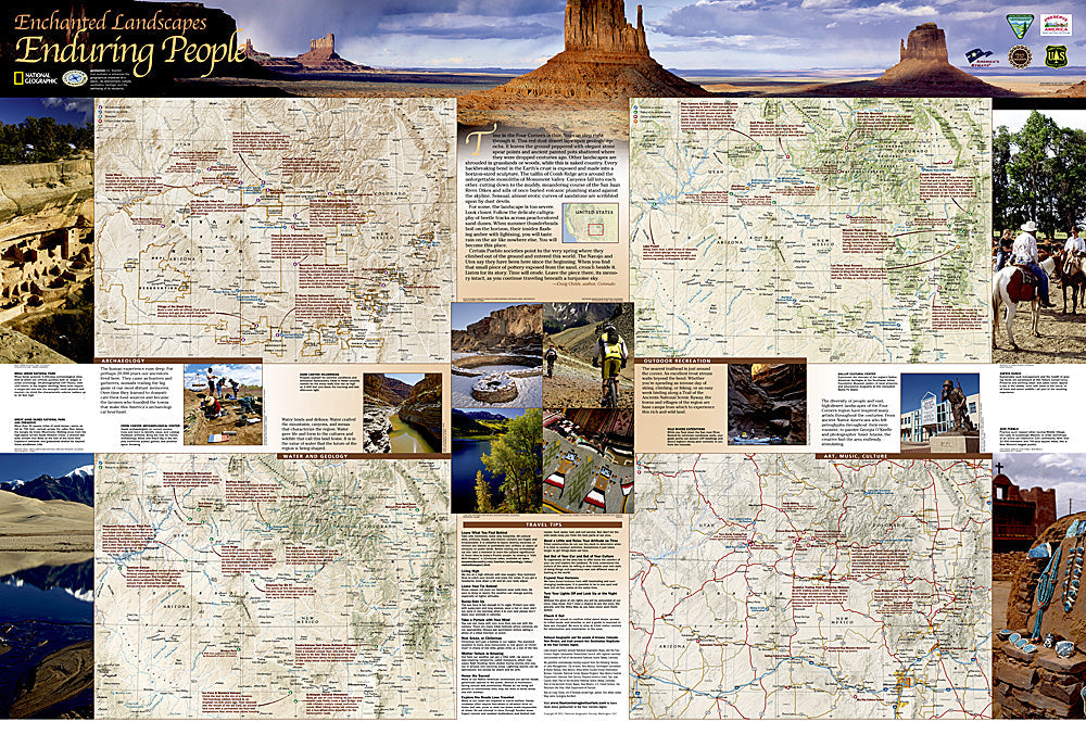
Four Corners Trail of the Ancients Destination Map
Four Corners Trail of the Ancients Destination Map
Couldn't load pickup availability
National Geographic Four Corners Trail of the Ancients Destination Map — waterproof, tear-resistant, detailed topography of the Trail of the Ancients, roads, 4WD trails, hiking paths, national parks, and ancestral puebloan sites. Folded 4" x 8.75".
The National Geographic Four Corners Trail of the Ancients Destination Map covers the region where Utah, Colorado, Arizona, and New Mexico meet — including Mesa Verde, Canyon de Chelly, Chaco Culture, Hovenweep, and Natural Bridges National Monuments. Roads, 4WD trails, hiking paths, and ancestral puebloan sites are mapped throughout.
Key specs
- SKU: NGDM002
- Coverage: Four Corners region (UT, CO, AZ, NM)
- Folded size: 4" x 8.75"
- Material: Waterproof, tear-resistant synthetic paper
Why it works
The Four Corners region's ancestral puebloan sites, national parks, and monuments are spread across a vast, remote desert landscape where accurate road and 4WD track detail is essential for safe navigation. Many sites require dirt road access that standard road maps don't show. The Trail of the Ancients Scenic Byway connects multiple sites across state lines — a single regional map covering the full route is far more practical than managing four separate state maps. Waterproof construction survives the desert heat and monsoon rain common in the Southwest.
Ideal for
History buffs, desert adventurers, and road trippers exploring the Four Corners' ancestral puebloan sites, national parks, and monuments. See also NGAM3121 (Southwest Adventure Map) for broader regional coverage.
Share