National Geographic
Washington D.C. City Destination Map
Washington D.C. City Destination Map
Couldn't load pickup availability
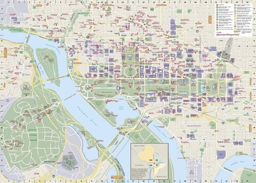
National Geographic City Destination Map of Washington D.C. — waterproof, tear-resistant, double-sided, comprehensive street map with 3D landmarks, metro map, airport diagrams, and street index. Scale 1:14,000. Folded 4.25" x 9.25".
The National Geographic Washington D.C. City Destination Map covers the city from Georgetown through the National Mall and Capitol to the Washington Navy Yard, with parts of Northern Virginia and the Potomac River. Hundreds of points of interest including monuments, hotels, parks, metro stations, and notable buildings — many depicted in 3D. Includes Old Town Alexandria inset, comprehensive metro map, Dulles and Reagan National Airport diagrams, and a full street and landmark index.
Key specs
- SKU: NGDC003
- Model: DC00620375
- Coverage: Washington D.C. and surrounding area
- Scale: 1:14,000 (city center)
- Folded size: 4.25" x 9.25"
- Flat size: 26" x 28"
- Material: Waterproof, tear-resistant synthetic paper
- Weight: ~4 oz
Why it works
Washington D.C.'s combination of a grid street system, diagonal avenues, and a dense concentration of monuments and museums makes navigation confusing without a detailed city map. The 3D landmark depictions help orient visitors who are navigating on foot between the Mall, Capitol, and surrounding neighborhoods. The metro map and airport diagrams eliminate the need for separate transit resources.
Ideal for
Tourists, business travelers, and history enthusiasts visiting Washington D.C.'s monuments, museums, and government buildings.
Share