National Geographic
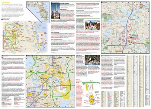
Orlando City Destination Map
Orlando City Destination Map
Couldn't load pickup availability
National Geographic City Destination Map of Orlando — waterproof, tear-resistant, double-sided, multi-scale maps including Walt Disney Resort, International Drive, and Downtown insets, plus Orlando Airport diagram and points of interest index. Folded 4.25" x 9.25".
The National Geographic Orlando City Destination Map presents the city at multiple scales — a Florida state overview, regional road map, city area map, and detailed insets of Walt Disney Resort, International Drive, and Downtown Orlando. Hundreds of hotels, theaters, parks, attractions, and points of interest are pinpointed. Includes Orlando Airport diagram, public transit overview, and indexed guides to cities, roads, hotels, attractions, and golf courses.
Key specs
- SKU: NGDC007
- Model: DC01020300
- Coverage: Orlando and surrounding area including Walt Disney Resort
- Folded size: 4.25" x 9.25"
- Flat size: 26" x 28"
- Material: Waterproof, tear-resistant synthetic paper
- Weight: ~4 oz
Why it works
Orlando's sprawling theme park complexes, resort corridors, and convention areas are spread across a large suburban footprint that's difficult to navigate without multi-scale mapping. The Walt Disney Resort and International Drive insets provide the street-level detail needed inside the resort areas, while the regional map shows the connections between them. The airport diagram helps visitors navigate Orlando International efficiently on arrival.
Ideal for
Tourists, families, and convention travelers visiting Orlando's theme parks, resorts, and attractions. See also NGDC002 (Miami & Keys) for South Florida coverage.
Share