National Geographic
Boston City Destination Map
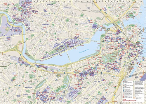
Boston City Destination Map
Couldn't load pickup availability
National Geographic City Destination Map of Boston — waterproof, tear-resistant, double-sided, detailed street map with 3D landmarks, Freedom Trail, MBTA subway map, Logan Airport diagram, and street index. Folded 4.25" x 9.25".
The National Geographic Boston City Destination Map covers hundreds of points of interest including monuments, notable buildings, churches, hotels, theaters, subway stations, parks, and hospitals — with 3D depictions of the Museum of Fine Arts, Faneuil Hall, and Fenway Park. Walking tours for the Freedom Trail, Black Heritage Trail, and Maritime Trail are mapped. Includes regional map, MBTA subway map, Logan Airport diagram, and a full street and landmark index.
Key specs
- SKU: NGDC005
- Model: DC00620541
- Coverage: Boston and surrounding area
- Folded size: 4.25" x 9.25"
- Flat size: 26" x 28"
- Material: Waterproof, tear-resistant synthetic paper
- Weight: ~4 oz
Why it works
Boston's historic street layout — one of the oldest in the US — doesn't follow a grid, making navigation by foot particularly challenging without a detailed city map. The Freedom Trail, Black Heritage Trail, and Maritime Trail routes are mapped directly on the street grid, eliminating the need for a separate walking tour guide. The MBTA subway map and Logan Airport diagram make this a single-resource solution for arriving and navigating the city.
Ideal for
Tourists, history enthusiasts, and business travelers visiting Boston's historic sites, universities, and neighborhoods.
Share