National Geographic
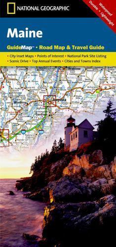
Maine Road Map & Travel Guide
Maine Road Map & Travel Guide
Couldn't load pickup availability
Waterproof, tear-resistant road map and travel guide for Maine — highways, scenic routes, Acadia National Park, lighthouses, and inset city maps. Scale 1:760,000.
The National Geographic Maine Guide Map combines a detailed road map with a curated travel guide for the Pine Tree State. Major highways, scenic byways, and secondary roads are clearly marked alongside hundreds of points of interest — national and state parks, campgrounds, visitor centers, airports, and ski areas. Inset maps cover Portland, Bar Harbor, Freeport/Yarmouth, Bangor, Augusta, and Lewiston-Auburn, with special coverage of Acadia National Park and the Lighthouses of Maine Scenic Drive.
Key specs
- SKU: NGGM032
- Scale: 1:760,000
- Folded size: 4" x 8.75"
- Flat size: 17.75" x 24.75"
- Material: Waterproof, tear-resistant synthetic paper
- Weight: ~1.3 oz
- Model: GM01020482
What's included:
- Full Maine road network with mileage markers and toll road designations
- Inset maps: Portland, Bar Harbor, Freeport/Yarmouth, Bangor, Augusta, Lewiston-Auburn
- Special coverage: Acadia National Park, Lighthouses of Maine Scenic Drive
- Points of interest: national/state parks, campgrounds, airports, ski areas, visitor centers, hospitals
- City, town, and county index
Why it works
Maine's coastline, Acadia National Park, and interior lakes and forests span a large, rural state where backroads and secondary routes are essential for reaching the best destinations. The 1:760,000 scale provides enough detail to navigate Maine's coastal peninsulas and island ferry connections that standard small-scale maps miss. Waterproof synthetic paper survives Maine's coastal fog, rain, and the humidity common throughout the state.
Ideal for
Road trippers, coastal tourists, and outdoor travelers exploring Maine's national parks, lighthouses, and scenic coastline.
Share