National Geographic
Colorado River, Kremmling to Glenwood: Map & Guide
Colorado River, Kremmling to Glenwood: Map & Guide
Couldn't load pickup availability
Waterproof fishing and river recreation map of 94 miles of the Upper Colorado River from Kremmling to Glenwood Springs — rapids, access points, fishing sites, and public lands.
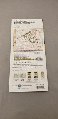
The National Geographic Fishing & River Map 2307 covers 94 miles of the Upper Colorado River from Kremmling through Gore Canyon to Glenwood Springs — one of Colorado's premier whitewater and fishing corridors. Class V+ rapids, hatch charts, stream flow information, fishing access points, river miles, public and private land boundaries, and recreation sites on waterproof, tear-resistant paper with a full UTM grid for GPS navigation.
Coverage includes:
- 94 miles of Upper Colorado River from Kremmling to Glenwood Springs
- Gore Canyon (Class V+ whitewater)
- Rapid classifications and locations
- Hatch charts and stream flow information
- River miles, put-ins, take-outs, and fishing access points
- Public vs. private land boundaries
- Recreation sites and campgrounds
Key specs:
- SKU: NGFR2307
- Scale: 1" = ½ mile (overlapping river-centered pages)
- Folded size: 4.25" x 9.38"
- Material: Waterproof, tear-resistant paper with stainless steel staples
- Full UTM grid for GPS navigation
- Weight: ~3.2 oz
Why it works:
The Upper Colorado through Gore Canyon is one of Colorado's most challenging and rewarding whitewater runs, and the broader Kremmling-Glenwood corridor offers exceptional fishing and float opportunities. The overlapping river-centered page layout makes it easy to follow the river's course without losing your place — essential when you're on the water.
Ideal for: Rafters, kayakers, and fly fishers on the Upper Colorado River from Kremmling to Glenwood Springs. See also NGFR2306 for the headwaters-to-Kremmling section.
Share